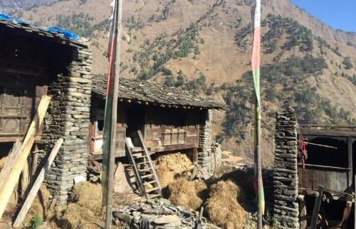
The Tamang Heritage Trail is a trekking route in the region between the Langtang National Park and the border of Tibet, rich of natural beauty and cultural sites. Starting in Syabru Bensi (also known as Syapru Besi) it goes through Gatlang, Tatopani, Nagthali at an altitude of more than 3000 m, down to Thurman, crossing the road to China and further up to Bridim and Langtang. From most of the parts along the trail you will see the impressive Langtang Mountain (Langang Lirung, 7234 m). The trail goes down into the valley, through stunning rhododendron forests, along vivid creeks and rivers, over hanging bridges and high up to the mountains with a tremendous view over the surrounding countryside and beautiful Himalaya peaks. In every village there are lovely guest houses with a rich variety of meals to offer. Stupas, temples and prayer flags at every corner remind constantly of the strong Buddhist tradition in this area.
The region was hit very badly by the earthquake in May 2015. Many of the lovely houses built out of stone bricks put on top of each other collapsed, among them big parts of Gatlang. Syabru Bensi and the road from Kathmandu to Tibet were touched by landslides. As of November 2015, Tatopani, given its name by the hot source and famous for its warm water pools, lost its main attraction as the hot water source stopped to pour out. People are building up houses again. Some of them will be finished soon and some other things will need even years to be fixed. People are sleeping in roughly built shelters on their crop land and praying in provisional temple places. Nevertheless there are still many lovely houses and cultural sites that remain standing embedded in this mystical landscape and didn’t lose any of their genuine charisma.